A common mistake Auckland construction teams make is assuming the volcanic soils and alluvial deposits behave uniformly under seismic loading. The reality is that the shear wave velocity profile can vary sharply within a single block in the CBD. Without a proper MASW survey, the VS30 value assigned to the site might be overestimated, leading to an unsafe seismic design category. Auckland sits on a mix of Waitemata Group sandstones, East Coast Bays Formation siltstones, and Holocene fills, each with distinct stiffness. A MASW / VS30 (shear wave velocity) investigation provides the actual velocity layering needed to classify the site per NZS 4203. Complementing this with a resistivity survey helps map deeper stratigraphy before drilling.
A single MASW line can reveal a VS30 difference of 100 m/s across 50 m of urban Auckland ground, altering the seismic design category entirely.
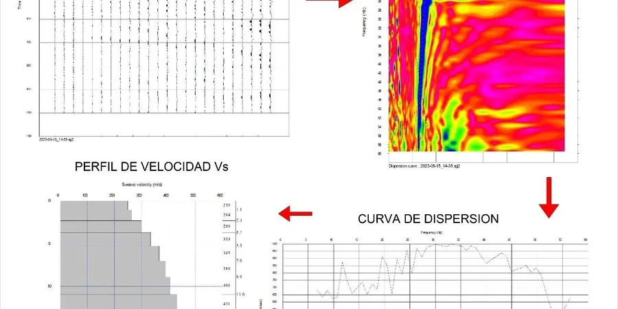
Method and coverage
The field crew deploys a 24-channel seismograph with 4.5 Hz geophones spaced at 2 m intervals along a linear array. A sledgehammer or accelerated weight drop generates surface waves that the geophones record. The equipment is set up on grass verges or asphalt, making it minimally invasive for Auckland's busy streets. The recorded data is processed in the frequency domain to extract the dispersion curve, then inverted to obtain the 1-D shear wave velocity profile down to 30 m. Key parameters measured include:
Rayleigh wave phase velocity dispersion curve
1-D Vs profile with depth increments
VS30 calculated as time-average to 30 m depth
Poisson's ratio from P- and S-wave velocities
The inversion is constrained by available borehole logs from nearby projects in the Auckland region. The final VS30 value directly feeds into the NZS 4203 site subsoil class.
Technical reference image — Auckland
Regional considerations
NZS 4203 requires that every building site be assigned a subsoil class (A through E) based on VS30 values. In Auckland, the risk is that shallow stiff crusts overlie softer layers, producing a misleadingly high VS30 if only surface methods are used. This happened on a recent project near the Manukau Harbour where a 5 m basalt cap gave a false class B, but the underlying alluvial silt dropped the VS30 to class D. A MASW survey catches that transition. The NZGS guidelines also recommend VS30 for liquefaction triggering assessments in the Auckland isthmus. Without it, the design spectrum may be non-conservative, especially for taller buildings sensitive to longer period motions. Pairing MASW with microtremor HVSR adds the resonant frequency needed for soil-structure interaction checks.
Vs profile, dispersion curve, site class per NZS 4203
Related services
01
2-D MASW Profile
Multiple receiver lines along a transect to produce a 2-D shear wave velocity section. Useful for mapping lateral variability across a site in the Auckland CBD or along a proposed road corridor.
02
1-D MASW for VS30
Single linear array focused on obtaining the VS30 value for seismic site classification. Standard deliverable includes the dispersion curve, inverted Vs profile, and NZS 4203 site class.
03
Active + Passive MASW
Combination of hammer source (active) and ambient noise recording (passive) to extend the depth range to 50–80 m. Ideal for deep foundations or high-rise buildings in the Auckland volcanic field.
04
MASW with Borehole Validation
MASW lines placed adjacent to existing or new boreholes to calibrate the inverted velocities against measured SPT N-values and soil descriptions. Provides a site-specific correlation for local Auckland formations.
Standards that apply
NZS 4402/D4428M-14 (Crosshole & downhole seismic testing — analogous MASW practice), NZS 4203:1992 (General structural design and design loadings — site subsoil class), NZGS Guidelines for the Assessment of Liquefaction (2016, 2021 supplement — VS30 use), NEHRP Recommended Provisions (VS30 site class boundaries)
FAQ
How does MASW differ from a standard SPT borehole for determining VS30?
MASW is non-intrusive and provides a continuous 1-D velocity profile from a single surface line, while SPT boreholes give discrete point measurements at limited depths. MASW captures the overall stiffness layering, including softer layers that might be missed between SPT test depths. In Auckland, where thin stiff crusts overlie softer sediments, MASW reveals the true VS30 without the spatial aliasing of a borehole log. The two methods are complementary: boreholes provide soil classification, and MASW provides the velocity profile.
What is the typical cost range for a MASW survey in Auckland?
The cost for a standard MASW survey in the Auckland region typically ranges between NZ$2,940 and NZ$5,820, depending on the number of lines, access conditions, and required depth. A single 1-D line with basic processing is at the lower end, while a 2-D profile or combined active-passive survey with detailed inversion pushes toward the upper end. Mobilisation fees may apply for sites outside the central isthmus.
Which Auckland soil types tend to produce lower VS30 values?
Holocene alluvial deposits along the Waitematā Harbour margins, soft estuarine clays near the Manukau Harbour, and loose volcanic ash layers in the Auckland Volcanic Field often yield VS30 values below 300 m/s, corresponding to NZS 4203 class D or even class E. In contrast, weathered Waitemata Group sandstone and basalt flows typically give VS30 above 500 m/s (class B or C). The variability is high, which is why a MASW survey is recommended even on sites with nearby data.
Location and service area
We serve projects across Auckland and surrounding areas.